Por Dr. Rodrigo Cañete
Versión en castellano
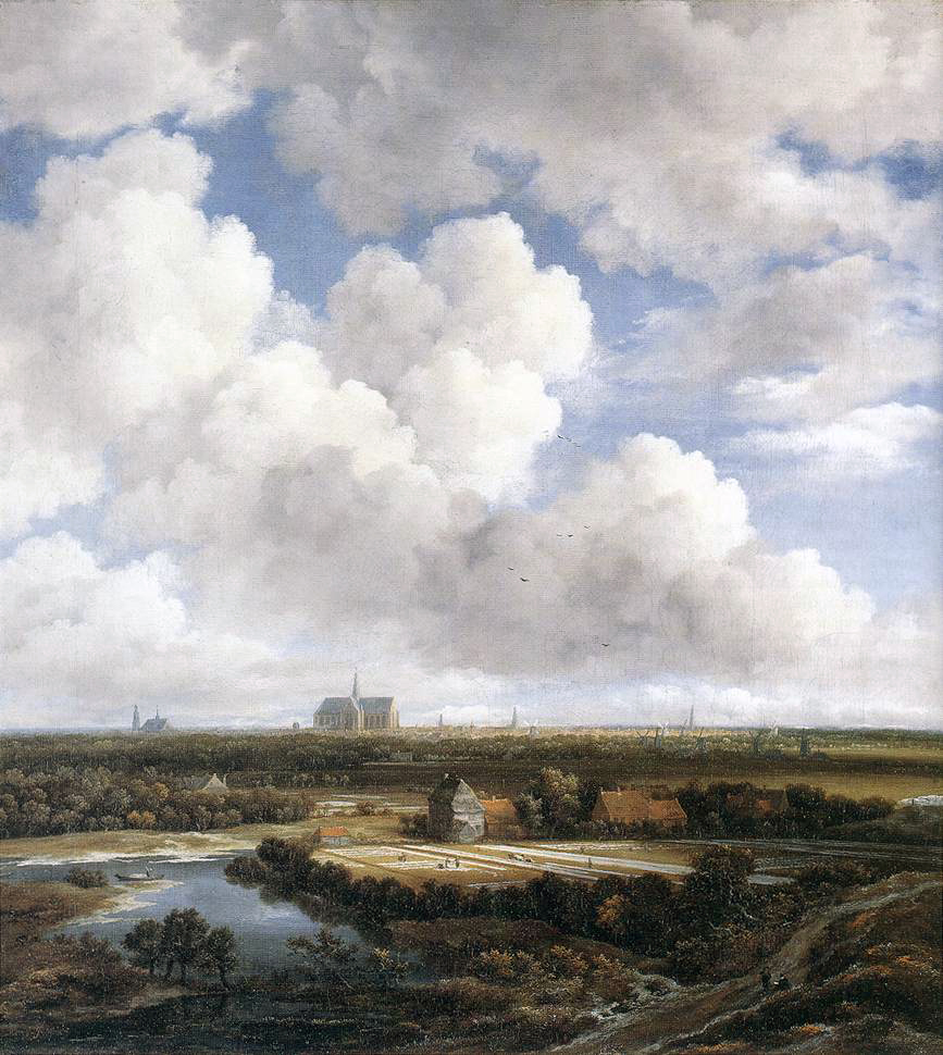
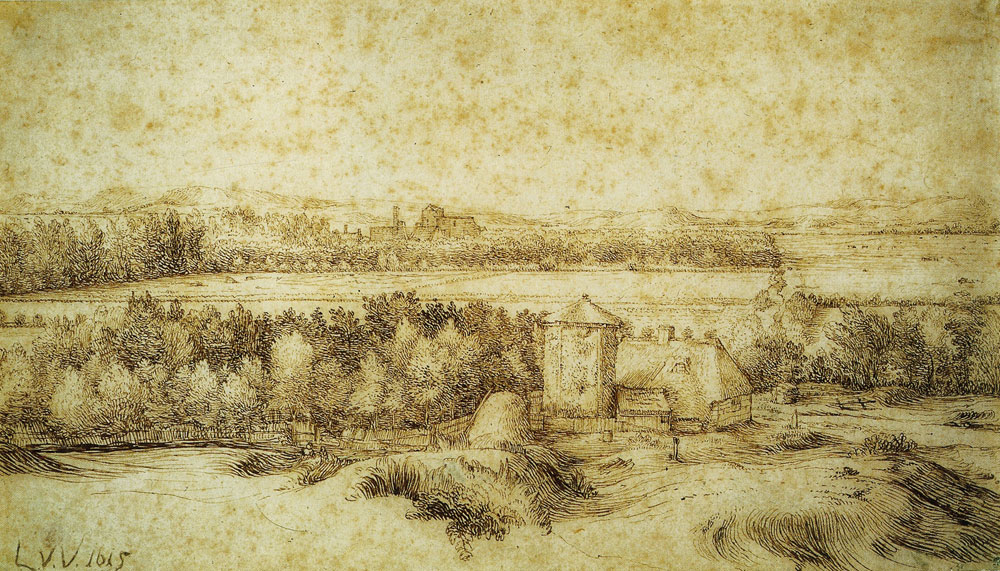
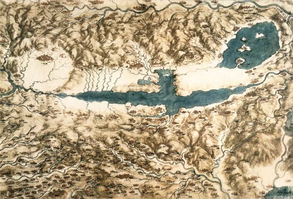
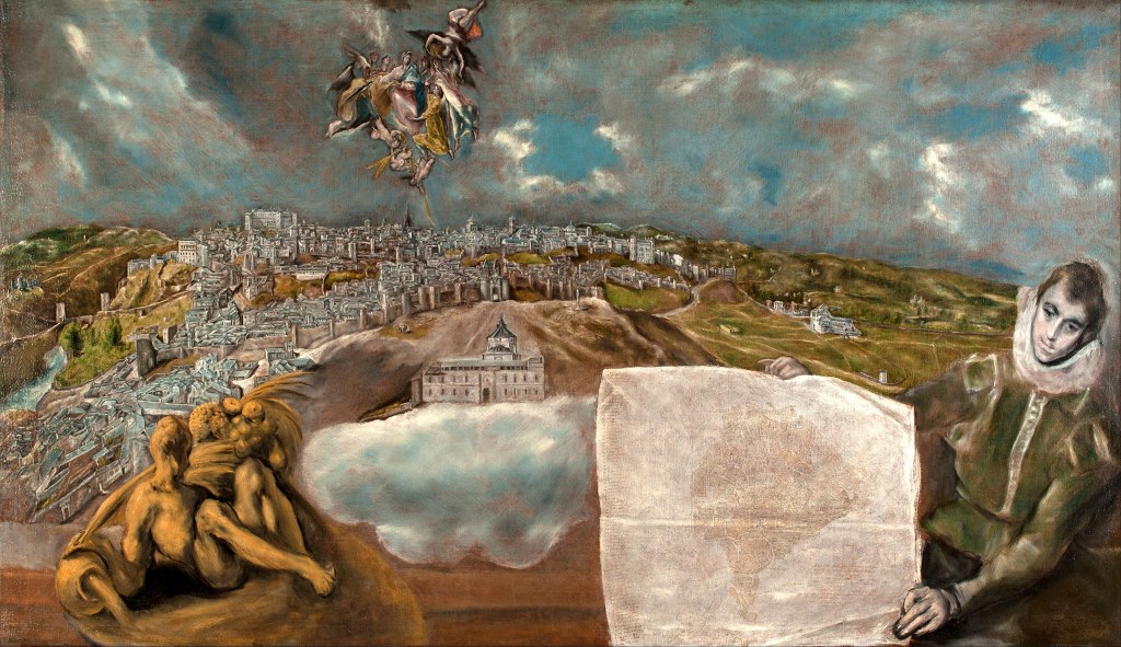
Hay una pregunta que recorre la historia del arte del paisaje desde el Renacimiento hasta el siglo XVII holandés, y que resuena con una urgencia inquietante en la Argentina de hoy: ¿quién tiene el poder de decir qué es un territorio y de quién es? En la clase que presentamos esta semana sobre topografía y el beau ideal, analizamos cómo el mapa y la pintura de paisaje no son instrumentos neutros de representación, sino tecnologías de poder. Lo que Leonardo da Vinci hacía cuando trazaba el Val di Chiana para Cesare Borgia, lo que Peeter Snayers hacía cuando convertía el sitio de Breda en un diagrama cartográfico con la Infanta Isabella Clara Eugenia como figura soberana, lo que Claes Jansz. Visscher hacía cuando publicaba sus Plaisante Plaetsen para una clase mercantil que necesitaba ver y poseer su territorio: todo eso era ejercer, a través de la imagen, una forma de soberanía sobre la tierra. El mapa no describe el territorio. El mapa lo construye, lo posee, lo argumenta.
Hay una pregunta que recorre la historia del arte del paisaje desde el Renacimiento hasta el siglo XVII holandés, y que resuena con una urgencia inquietante en la Argentina de hoy: ¿quién tiene el poder de decir qué es un territorio y de quién es?
Tweet
Esa lección histórica se vuelve políticamente urgente cuando miramos lo que está ocurriendo hoy en Argentina con las leyes de tierras y con las narrativas que circulan sobre ellas. El gobierno de Javier Milei ha propuesto modificaciones significativas al marco regulatorio que desde 2011 limitaba la propiedad extranjera de tierras rurales al 15% por zona geográfica, bajo la Ley 26.737. Las desregulaciones propuestas forman parte de una agenda libertaria más amplia que concibe la tierra como un activo económico más, sujeto a las leyes del mercado sin restricciones de nacionalidad o de interés estratégico nacional. Independientemente de la posición que se adopte frente a esa política, es una discusión legítima y documentable sobre el modelo de desarrollo y la soberanía territorial argentina. Es, en términos de nuestra clase, una discusión sobre quién tiene el poder de trazar el mapa.
Lo que no es legítimo ni documentable es lo que ocurre en paralelo en las plataformas digitales: una cascada de desinformación que afirma, sin ningún sustento documental, que el Estado de Israel o ciudadanos israelíes están comprando masiva y sistemáticamente tierras públicas en la Patagonia argentina. No existe ningún registro oficial, ningún expediente de catastro, ningún instrumento legal que respalde esa afirmación. Los datos de catastro indican que la propiedad extranjera en Argentina ronda el 5% a nivel nacional, y que los principales propietarios foráneos registrados provienen de Estados Unidos, Italia y España. Gran parte del territorio patagónico que los rumores señalan como “en venta” corresponde a Parques Nacionales, áreas protegidas por ley donde es ilegal realizar loteos o urbanizaciones privadas. Los expedientes que circulan en videos virales tienen códigos inexistentes. El llamado “barrio privado Josué” nunca existió. Tanto el gobierno argentino como la Embajada de Israel lo han desmentido categóricamente.
Lo que no es legítimo ni documentable es lo que ocurre en paralelo en las plataformas digitales: una cascada de desinformación que afirma, sin ningún sustento documental, que el Estado de Israel o ciudadanos israelíes están comprando masiva y sistemáticamente tierras públicas en la Patagonia argentina
Tweet

Estas narrativas falsas no son nuevas ni inocentes. Se enraízan directamente en el llamado “Plan Andinia”, un mito antisemita que circula desde la década de 1970 y que afirma falsamente la intención de fundar un Estado judío en el sur argentino. La desinformación contemporánea sobre mochileros israelíes, sobre supuestas filtraciones diplomáticas, sobre proyectos de colonización encubiertos, es la versión digitalizada y acelerada de ese mismo mito. Y aquí es donde la historia del arte nos ofrece una herramienta analítica precisa: en nuestra clase vimos cómo Erwin Panofsky describió el problema del “simbolismo disfrazado” en la pintura neerlandesa, donde los objetos naturales pueden estar cargados de significados ocultos que el espectador no iniciado no puede detectar. La desinformación conspirativa opera con la lógica exactamente inversa: proyecta sobre el territorio un significado oculto que no está ahí, convierte la presencia de turistas israelíes en el sur argentino en evidencia de una conspiración, lee en el mapa una intención que el mapa no contiene.
Lo que conecta el análisis histórico con el presente político no es una analogía decorativa. Es una continuidad estructural. El mapa siempre fue un instrumento de disputa sobre la soberanía territorial. En el siglo XVII, la cartografía holandesa era simultáneamente arte, comercio e instrumento de construcción de identidad nacional frente al poder imperial español. Hoy, en Argentina, la disputa sobre quién puede poseer la tierra y en qué condiciones es una disputa legítima sobre el modelo de nación. Pero esa disputa legítima está siendo colonizada por narrativas falsas que, en lugar de criticar las políticas de desregulación con argumentos documentados, desvían la atención hacia un enemigo imaginario con raíces en el antisemitismo más clásico. El mapa se convierte en arma dos veces: una vez en manos de quienes trazan políticas territoriales sin debate democrático suficiente, y otra vez en manos de quienes fabrican geografías del miedo para sustituir el análisis por el prejuicio. Reconocer esa diferencia no es un detalle menor. Es, precisamente, lo que hace la historia del arte cuando se toma en serio.
El mapa se convierte en arma dos veces: una vez en manos de quienes trazan políticas territoriales sin debate democrático suficiente, y otra vez en manos de quienes fabrican geografías del miedo para sustituir el análisis por el prejuicio.
Tweet
THE MAP AS WEAPON: israel, antisemitism, SOVEREIGNTY, AND THE LIES ABOUT the LAND
There is a question that runs through the history of landscape art from the Renaissance to seventeenth-century Holland, and that resonates with unsettling urgency in Argentina today: who has the power to say what a territory is and to whom it belongs? In the class we are presenting this week on topography and the beau ideal, we examine how the map and the landscape painting are not neutral instruments of representation but technologies of power. What Leonardo da Vinci was doing when he mapped the Val di Chiana for Cesare Borgia, what Peeter Snayers was doing when he turned the Siege of Breda into a cartographic diagram with the Infanta Isabella Clara Eugenia as the sovereign figure, what Claes Jansz. Visscher was doing when he published his Plaisante Plaetsen for a mercantile class that needed to see and possess its territory: all of that was exercising, through the image, a form of sovereignty over the land. The map does not describe the territory. The map constructs it, possesses it, argues for it.
That historical lesson becomes politically urgent when we look at what is happening in Argentina today with land laws and the narratives circulating about them. The government of Javier Milei has proposed significant modifications to the regulatory framework that since 2011 limited foreign ownership of rural land to 15% per geographic zone, under Law 26.737. The proposed deregulations are part of a broader libertarian agenda that conceives of land as one more economic asset, subject to market laws without restrictions of nationality or national strategic interest. Whatever position one takes on that policy, it is a legitimate and documentable debate about Argentina’s development model and territorial sovereignty. It is, in terms of our class, a debate about who has the power to draw the map.
What is neither legitimate nor documentable is what is happening in parallel on digital platforms: a cascade of disinformation claiming, without any documentary basis, that the State of Israel or Israeli citizens are massively and systematically buying public lands in Argentine Patagonia. There is no official record, no cadastral file, no legal instrument that supports that claim. Cadastral data indicate that foreign ownership in Argentina hovers around 5% nationally, and that the main registered foreign owners come from the United States, Italy and Spain. Much of the Patagonian territory that rumors identify as “for sale” corresponds to National Parks, areas legally protected where private subdivision or development is illegal. The files circulating in viral videos carry non-existent codes. The so-called “Josué private neighborhood” never existed. Both the Argentine government and the Israeli Embassy have categorically denied these claims.
These false narratives are neither new nor innocent. They are rooted directly in what is known as the “Plan Andinia,” an antisemitic myth circulating since the 1970s that falsely claims an intention to found a Jewish state in southern Argentina. The contemporary disinformation about Israeli backpackers, supposed diplomatic leaks, and covert colonization projects is the digitized and accelerated version of that same myth. And this is where art history offers us a precise analytical tool: in our class we saw how Erwin Panofsky described the problem of “disguised symbolism” in Netherlandish painting, where natural objects can be charged with hidden meanings the uninitiated viewer cannot detect. Conspiratorial disinformation operates with exactly the inverse logic: it projects onto the territory a hidden meaning that is not there, turns the presence of Israeli tourists in southern Argentina into evidence of a conspiracy, reads into the map an intention the map does not contain.
What connects the historical analysis to the political present is not a decorative analogy. It is a structural continuity. The map has always been an instrument of dispute over territorial sovereignty. In the seventeenth century, Dutch cartography was simultaneously art, commerce, and an instrument for constructing national identity in opposition to Spanish imperial power. Today, in Argentina, the dispute over who may own land and under what conditions is a legitimate argument about what kind of nation Argentina wants to be. But that legitimate dispute is being colonized by false narratives that, rather than criticizing deregulation policies with documented arguments, redirect attention toward an imaginary enemy with roots in the most classical forms of antisemitism. The map becomes a weapon twice: once in the hands of those who draft territorial policies without sufficient democratic debate, and again in the hands of those who fabricate geographies of fear to substitute prejudice for analysis. Recognizing that difference is not a minor detail. It is, precisely, what art history does when it takes itself seriously.


Deja una respuesta